Brace yourself. We're about to enter the Winter Weather Twilight Zone. We're going to go from a balmy 63 degrees this afternoon to as much as 4-8 inches of snow just a few hours later.
 No, you did not go to sleep last night and wake up two months from now.
Yes, it is 60 degrees out.
I had one of those "What the...." moments when I walked out the door in the pre-dawn darkness this morning. It absolutely felt like April.
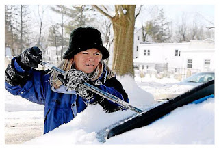
Don't worry. It's not going to last. In fact, this time tomorrow we are expecting snow - likely accumulating snow on cars, yards and other surfaces.
Call it a case of winter weather whiplash.
We'll be pushing record highs today - maybe as high as 63 degrees.
Then tonight we'll have showers, then a rush of cold air moving in and changing the rain to snow.
The National Weather Service has posted a Winter Storm Warning for most of the region, from 4 a.m.to 4 p.m.
Snow will be falling heavily in the a.m. hours, making the morning rush a mess.
Here's the key: I'm hoping maybe all that warm air sticks around longer than expected, and most of this wet, sloppy snow does not stick to the roads. I don't like it, but if we have to deal with it, I'd rather it be on my car and the lawn than on the roads.
Temperatures will be plunging tonight, dropping as much as 30 degrees into the low 30s. That is what is going to trigger the snow. Most forecasts are calling for anywhere from 4-8 inches, with as usual more snow falling north and west.
Which reminds me, can someone tell me exactly where those mysterious "northern and western suburbs" are?
My advice. Go outside and enjoy today.
Then go to bed, pull the covers up over your head, and don't come out again until Friday morning.
Just pretend Thursday does not exist this week.
You can get our full forecast here.
No, you did not go to sleep last night and wake up two months from now.
Yes, it is 60 degrees out.
I had one of those "What the...." moments when I walked out the door in the pre-dawn darkness this morning. It absolutely felt like April.
Don't worry. It's not going to last. In fact, this time tomorrow we are expecting snow - likely accumulating snow on cars, yards and other surfaces.
Call it a case of winter weather whiplash.
We'll be pushing record highs today - maybe as high as 63 degrees.
Then tonight we'll have showers, then a rush of cold air moving in and changing the rain to snow.
The National Weather Service has posted a Winter Storm Warning for most of the region, from 4 a.m.to 4 p.m.
Snow will be falling heavily in the a.m. hours, making the morning rush a mess.
Here's the key: I'm hoping maybe all that warm air sticks around longer than expected, and most of this wet, sloppy snow does not stick to the roads. I don't like it, but if we have to deal with it, I'd rather it be on my car and the lawn than on the roads.
Temperatures will be plunging tonight, dropping as much as 30 degrees into the low 30s. That is what is going to trigger the snow. Most forecasts are calling for anywhere from 4-8 inches, with as usual more snow falling north and west.
Which reminds me, can someone tell me exactly where those mysterious "northern and western suburbs" are?
My advice. Go outside and enjoy today.
Then go to bed, pull the covers up over your head, and don't come out again until Friday morning.
Just pretend Thursday does not exist this week.
You can get our full forecast here.

Comments